
Where the Sun Slips and the Land Remembers: The Parowan Gap
- Nicole
- Dec 24, 2025
- 4 min read


When you think of one of North America’s greatest archaeological treasures, a place that holds one of the earliest known complex calendar systems, dating back to 3000 B.C., the small town of Parowan, Utah probably isn’t the first place that comes to mind. And yet, tucked quietly into the red rock hills of southern Utah is a narrow opening in the mountains where time, sky, and stone have been speaking to one another for thousands of years.
Welcome to Parowan Gap.
Locals simply call it The Gap, but this 600-foot natural break in the rock is far more than a scenic pass. It is a living calendar, a sacred gathering place, and a vast stone archive shaped by the hands and observations of the Hopi, Paiute, and other Indigenous peoples who lived, traveled, and worshipped here long before roads, fences, or town names existed.
Along the rock walls of the Gap, visitors will find a remarkable open-air gallery: more than 1,500 petroglyphs across roughly 90 panels, each telling fragments of stories that span generations — migration, ceremony, survival, and an intimate relationship with the sky above.

Today, archaeologists continue to study Parowan Gap not just as an art site, but as an astronomical and ceremonial landscape. Many believe the petroglyphs align precisely with solar and lunar cycles, marking solstices, equinoxes, and seasonal transitions critical to life in an arid environment.
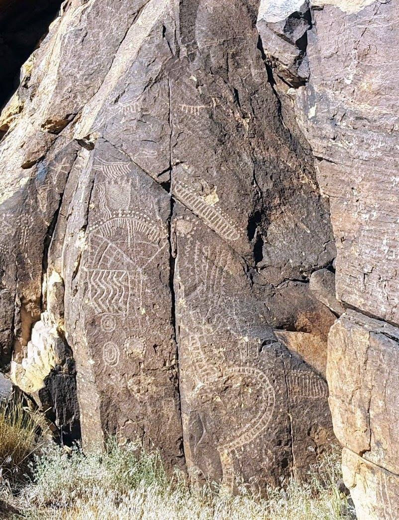
This was not art for art’s sake. For the people who lived here, these markings were tools, a way to track time, predict weather, guide movement, and ensure survival. The calendar etched into the stone was as essential as water or shelter.
One of the most discussed features is the Zipper Glyph, long believed to function as a solar marker. From a distance, its shape echoes the form of the Gap itself — a reminder that landscape and symbol are inseparable here. Nearby petroglyphs depict lunar cycles, including quarter moons and full moons, reinforcing the site’s role as a celestial map.

During the summer solstice, something remarkable happens.
As evening approaches, the sun appears to slide down the rock face, lingering briefly in a notch between the two mountain walls before disappearing from view. It is subtle, quiet, and powerful all at once — like a natural clock chiming the end of a season.
For ancient peoples, this moment signaled change. A shift in time. A reminder that the year was turning. Then there is the Overseer. If you look closely, you’ll notice an outcropping of rock that resembles a face watching over the Gap. At certain times of the year, the sun settles perfectly into the Overseer’s open mouth. As it sinks, the stone figure appears to swallow the sun — a dramatic and unforgettable signal that winter is coming.
On rare and lucky nights, the same phenomenon happens with the moon.

Parowan Gap cannot be understood by isolating one glyph, one rock, or one moment in time. Its meaning lives in the relationship between everything: the land, the sky, the stories, and the people — past and present.

Today, the Parowan Heritage Foundation works in partnership with the Bureau of Land Management, the Paiute Tribe of Utah, the Hopi Tribe, archaeologists, and dedicated volunteers to protect and preserve this sacred site. Their work ensures that Parowan Gap remains a place of learning, respect, and wonder rather than exploitation.
Here, the rocks remember. And if you slow down long enough, they just might teach you how to listen.
Standing in the Gap as the sun slips away or the moon aligns just right, it becomes clear: this is not just a historical site. It is a reminder that time was once measured not by clocks, but by light, shadow, and patience.
How to get to the Parowan Gap:
GPS Coordinates:Petroglyphs: N37° 54' 35", W112° 59' 08"Dinosaur Tracks: N37° 53' 49", W112° 57' 03"From Cedar City: Go north on Main (or take Interstate 15 Exit 62) to UT 130. Continue north 13.5 miles, then turn east (right) 2.5 miles on a good gravel road to Parowan Gap.From Parowan: Go north on Main to 400 North. Turn west (left) for 10.5 miles on good gravel road (near Milepost 19).


What You’ll Remember
The walls of the Parowan Gap are steep weathered and fractured Navajo sandstone. There are an impressive number of panels covered in petroglyphs. Some are recognizable as animals and humans, but mostly they are shapes. Circles, spirals, lines, and dots all collide and overlap giving you the sense that some of the petroglyphs are newer than others.
Walking from east to west you will make your way along the northern side then cross the road and head back. The south side has only a few petroglyphs and you can also see where the names and initials of pioneer settlers have been carved.
When to Visit:
Early or late in the day offers the best viewing of the petroglyphs.
Watching the sunset from there is highly recommended.
Head out on the summer solstice - make sure to take plenty of water, a hat and sunscreen.
Parowan Gap is a powerful and fragile place, and visiting responsibly helps protect it for future generations. Stay on established paths, never touch or climb on the petroglyph-covered rocks, and leave everything exactly as you find it. Pack out all trash, keep noise low, and remember this is a sacred cultural site, approach it with respect, curiosity, and care.

Comments